Envision Technologies creates stay, work, play in one Londonderry site
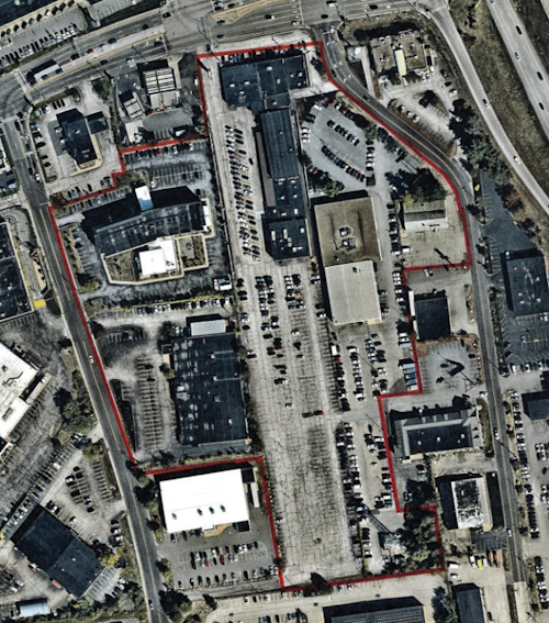
The 110-acre Village at Technology Park off Harvey Road in north Londonderry will include space for industrial, residential, childcare and retail.
Recent severe flooding in New Hampshire — which resulted in the governor declaring a state of emergency in five counties — allows a glimpse at some of the geological forces that shape our planet and continually change the environment.
A flood event is like watching geology on fast forward. What may normally take tens to thousands of years to occur can take place in a few minutes.
The New Hampshire flood of 2005 resulted in loss of life, damage to private property, destruction of homes and businesses, severe damage to public infrastructure (including roads, bridges, drainage structures and government facilities), damage to communication lines, extensive erosion, contamination of drinking water, loss of agricultural productivity and psychological trauma. It also triggered mudslides in several areas across New Hampshire.
Storm damage resulted in 57 miles of state roads being closed on Oct. 9, 2005. One day later, 43 miles of road were open for emergency vehicles and local traffic, while 14 miles remained closed. On Oct. 19, only 4.5 miles were closed, 29 miles were open and 23.5 miles were open for emergency vehicles/local traffic. Due to safety concerns and access difficulties, seven NHDOT bridge inspection teams were mobilized to inspect over 170 bridge structures across the state. Other NHDOT teams were mobilized to inspect roads, drainage structures and slopes throughout the state. The most severe and widespread damage occurred in the village of Alstead, along Routes 123 and 12-A.
Most engineered structures, embankments and drainage systems are designed for a 100-year flood. The heavy rainfall and related events that occurred during October 2005 exceeded the established limits for normal engineering design.
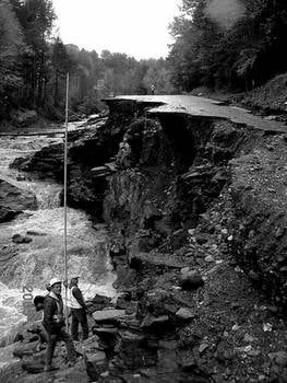
Warren Brook flowed through a 12-foot-diameter culvert that extended underneath a 30-foot-high embankment fill at Cooper Hill Road, approximately two miles upstream from Alstead village. Damage from the floodwater extended from Cooper Hill Road to where the Cold River empties into the Connecticut River, a distance of approximately 7.5 miles. A total of 36 buildings were completely destroyed and 71 homes sustained varying degrees of damage.
Along both sides of Warren Brook and the Cold River, acres of farmland were completely stripped of topsoil and/or covered with all types of flood debris. Cars were carried thousands of feet downstream, some perched in trees and others crushed like aluminum cans. Portions of foundations and concrete slabs were undercut, leaving buildings precariously overhanging eroded stream banks. Several buildings were ripped from their foundations, large trees uprooted, roads washed out, bridges carried away, and at some locations the overlying soil was stripped to bedrock. Concrete foundations were all that remained of several houses.
In some instances, the current was so strong it removed the upper layer of fractured bedrock. Segments of paved roadway, hundreds of feet in length, were swept away. In some areas, the stream channel had been rerouted to where the road originally existed. Other areas were buried under assorted debris and soil deposits with boulders three to four feet in diameter — a river bottom current velocity of at least 38 feet per second is needed to move boulder size material.
Clear water with little suspended matter has a limited capacity for abrasive action. When running water transports sand- to pebble-size particles, it becomes a powerful agent of erosion. A combination of sheet runoff and stream erosion were responsible for roadway washouts, loss of homes, damage to drainage structures and severe erosion just down stream from the Warren Lake Dam.
Extent of damage
Flood-related damage to roads and bridges across the state is estimated to be more than $25 million. Some locations were repaired within hours or days, while other sites are expected to take weeks to months.
The most difficult roadway sites to repair in the Alstead area are a 400-foot-long segment of Route 123 along Warren Brook, just west of its intersection with Route 12-A and portions of Route 123 at the Cooper Hill Road intersection.
Temporary repairs at the site downstream from the Route 12-A intersection involves the placement of stone fill in areas where the road has been washed out. Anchorage may be needed for large rocks placed along the toe of the embankment. A geotextile will be installed between the existing soil and the stone fill.
Two alternative designs are being considered for permanent repairs at this location. The first alternative involves the construction of a 400-foot-long retaining wall along Warren Brook. The wall would reach a maximum height of approximately 25 feet. The second alternative would be to cut into the steep hillside on the opposite side of the road and move Route 123 away from the brook. The geologic conditions, feasibility of construction and cost for both alternatives will be compared.
Several stream crossings have been spanned with temporary Bailey bridges, while plans are underway to build new replacement structures. The bridge over Cold River in Alstead has settled approximately nine inches at the south end. Borings are planned to determine if voids exist beneath the southern abutment. The scope of repairs for this structure will depend on the subsurface conditions. It was reported that floodwater washed over the bridge at a height of four feet above the deck. An eyewitness stated that a wrecker truck carried by the floodwater crashed into the bridge, flipped over the bridge and then was swept further downstream.
Accounts describing the devastation in Alstead provide some insight into the awesome power of flooding as a geologic process. These events are a frightening reminder that even a small brook, under the right conditions, can become a destructive force as well as a powerful erosional agent.
Richard Lane is a research geologist in the Department of Transportation’s Bureau of Materials and Research. This article originally appeared in the New Hampshire Good Roads Association’s New Hampshire Highways magazine.
The 110-acre Village at Technology Park off Harvey Road in north Londonderry will include space for industrial, residential, childcare and retail.

At Blueline Advisors in Exeter, chief investment officer Frank Sabin is embracing AI, with the help of the students, to better serve his clients, who have entrusted about $250 million in assets in his care.

As Granite Staters eye ever-increasing purchase prices for a single-family home, state and federal policy makers wrestle with solutions that create more housing supply. Among them is bipartisan federal legislation on housing that is being held hostage by President Donald Trump’s fixation on a bill that would require voters to provide proof of citizenship with such documents as U.S. passports or birth certificates.

Two New Hampshire cities are among the 10 best-run cities in the country, according to a WalletHub analysis of U.S. communities where residents get the most bang for their taxes. Manchester was rated No. 3, while Nashua was close behind at No. 5., based on a “Quality of Services” score that WalletHub developed using 36 metrics across six key service areas — financial stability, education, health, safety, economy and infrastructure/pollution.

Business and event happenings around the state of NH

The Latest is a roundup of the comings and goings of the movers and shakers in NH's business community
A brand new and redesigned Revo Casino and Social House came back to Manchester’s land-use boards this month after the acquisition of additional nearby properties allowed the creation of an expanded vision for the project.
The New Hampshire House and Senate sent three bills to Gov. Kelly Ayotte intended to enable more housing construction, overcoming opposition from the New Hampshire Municipal Association and others.

HEALTH CARE By: DR. STEVEN ANGELO As more Americans live longer, maintaining brain health is becoming an increasingly important part of overall well-being. During Alzheimer’s & Brain Awareness Month, and throughout the year,…